Present-day kinematic motion of Anatolia
This blog post describes the present-day tectonic motion of Anatolia with respect to the AT-EU Euler Pole and its implications for the Aegean Sea.
Published on March 26, 2023 by Fabian Kutschera
tectonics anatolia eurasia
2 min READ
The present-day kinematic motion of Anatolia is impressive. As shown in the figure below, the motion at regional GNSS (Global Navigation Satellite System) stations indicates a clear circular counterclockwise rotation towards the Hellenic Arc subduction zone with respect to the Anatolia-Eurasia (AT-EU) Euler pole. Some sites even move with up to 4 cm/year [England et al., 2016].

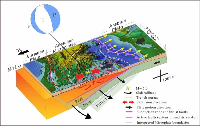
The Anatolian Plate is surrounded by several larger tectonic plates, namely the Eurasian Plate to the north, the African Plate to the south and the Arabian Plate to the east [Bird, 2003]. In the west, the Anatolian Plate adjoins to the Aegean Sea Microplate, which is characterized by active tectonic deformation and frequent earthquake activity. Here, high rates of seismicity are present at the Hellenic subduction zone, where the northeast-moving African Plate sinks with varying subduction rates beneath the Aegean Sea. Consequently, very devastating historical events have occurred, such as the AD 365 and 1303 Crete earthquakes, both resulting in magnitudes >=8 and causing widespread damage due the generation of a tsunami. However, earthquake occurrence is also frequent north of the Hellenic Trench within the complex tectonic Aegean Sea region, which is subject to moderate-to-large earthquakes. A recent example includes the 2020 Mw 7.0 Samos earthquake, which ruptured on an E-W striking north-dipping normal fault in an area exposed to extensional faulting. The corresponding tectonic regime is mostly driven by slab rollback, which means that the African Plate drags and tears the upper Aegean Sea Microplate apart, leading to back-arc extension and crustal stretching in the Aegean Sea. These N-S divergent acting forces create E-W oriented basins and graben structures with both north and south dipping faults. The next figure summarizes the regional tectonic setting in the context of the Samos earthquake [Meng et al., 2021].
This concludes this blog post for now. No liability is taken for the accuracy, completeness or timeliness. Are you curious how the title figure was created? Check out How to use GIMP for figure processing.
References
- Bird, P.: An updated digital model of plate boundaries, Geochemistry, Geophysics, Geosystems, 4, https://doi.org/10.1029/2001GC000252, 2003
- England, P., Houseman, G., and Nocquet, J. M.: Constraints from GPS measurements on the dynamics of deformation in Anatolia and the Aegean, Journal of Geophysical Research: Solid Earth, 121, 8888–8916, https://doi.org/10.1002/2016JB013382, 2016
- Meng, J., Sinoplu, O., Zhou, Z., Tokay, B., Kusky, T., Bozkurt, E., and Wang, L.: Greece and Turkey Shaken by African tectonic retreat, Scientific Reports, 11, 1–10, https://doi.org/10.1038/s41598-021-86063-y, 2021